Based on GeoMixer platform
Geoinformation system (GIS) helps to organize spatial data for many use cases: from search data to sharing maps and coworking. It can be implemented as one of the components of more complicated entire Information system. GeoMixer is a robust and scalable platform for online maps and GIS solutions for which we offer a flexible pricelist and annual support.
How does it work ?
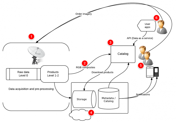
- Imagery acquisition and preprocessing tools
- Panchromatic or bundle products converted into JPEG raster layers. In addition to quicklooks, these allow users to preview imagery in full resolution or limited by zoom levels, to download fragments, or to get imagery as a service for third-party applications
- The main GeoMixer-based user application serves to search imagery using a number of filters, to preview images on top of interactive basemaps, to upload AOI shapefiles, etc.
- The storage of imagery products (as files) and metadata (as databases) can be deployed in the cloud or in the enterprise network.
- Notifications of imagery updates for certain areas of interest predefined by user subscriptions.
- Third-party applications users who can get access to RGB imagery and metadata via standard program interfaces like WMS / WFS.
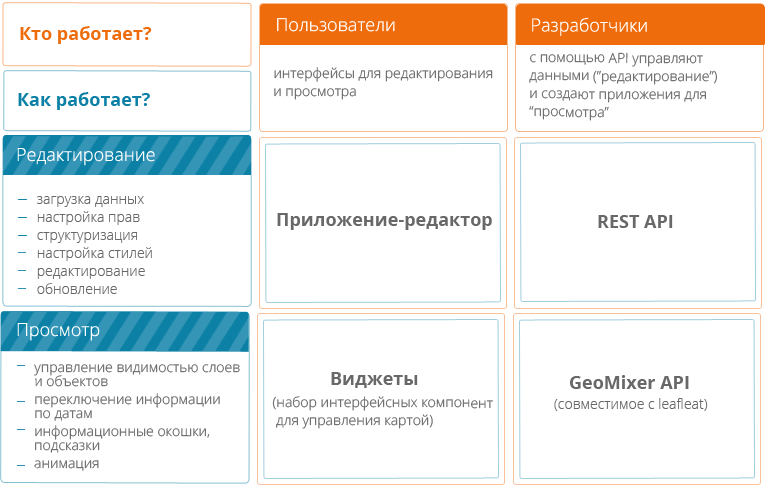
GeoMixer Editor
The application is designed to perfom main operations with spatial data: upload, customize styles, delegate rights etc. Also is used as base UI viewer to browse created maps, to interact with data and to use tools and services.
GeoMixer API
Program interface to embed GeoMixer maps into client-side applications, customize user interface and to add additional components and plugins.
GeoMixer Server
GeoMixer's backend to manage data into Database, to optimize it for better perfomance and many more Server-side operations like WMS, WFS data export and so on ..
GeoMixer platform for enterprise GIS development
- Amazing web-based perfomance of big data in vector formats (like gpx tracks. multitemporal data like tracking or satellite imagery)
- Propriatary or opensource backend environment (MS SQL Server / Prostgre SQL)
- Scalable architecture for enterprise and cloud-base solutions
- Base maps and open data (like Openstreetmap)
- Easy customizable UI using API and opensource components like Leaflet
- Tech support and users community, tutorilas, case studies, webinars
Use individual method and learn from others. We can analyze your business taks and consult you regarding best practice of GIS integration and usage.
Case Studies
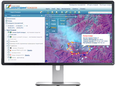
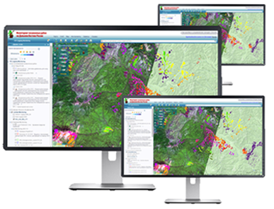
Russian Geoportal «Kosmoplan»
Multipoject system to support decision makers and operators in Emercom. Contains various data sets and connection services. Pluged with VPN into Scanex network to get the operative satellite imagery acquired and processed by Scnaex.
Publication
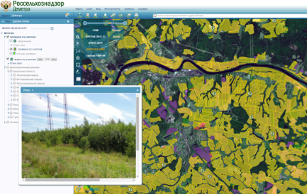
GIS for agriculture control "Demetra"
The united system for agriculture activities control by "Rosselhoznadzor". Integrates several subsystems for information support of state control.
View
in Blog (in Russian)
Publication
What is GeoMixer Cloud?
Many of successful technologies are migrating to the clouds not mention ones to be born in the cloud. This way allows continuously software updates and more flexible scaling. Software as a service (SaaS) hosted in scalable (cloud) infrastructure means you don't need to deploy and maintain your own infrastructure to work with GeoMixer and to store your data. All can be depoyed in the Cloud. GeoMixer Cloud is launched on SCANEX server cluster it also can be deployed on Postgres based cluster provided by third-party cloud hosting like Amazon or even by your own enterprise network provider. Yet if your company already has its own infrastructure or the data policy doesn't allow to store data on external storages GeoMixer can be deployed locally with the same architecture.
GeoMixer Cloud components
GeoMixer Editor
The application is designed to perfom main operations with spatial data: upload, customize styles, delegate rights etc. Also is used as base UI viewer to browse created maps, to interact with data and to use tools and services.
REST API
"Cloud" doesn't mean you cann't connect it with your local data. It can be synchronized with GeoMixer layers using REST API protocol via HTTPS connection. For example to update transport locations on the map.
Widgets
UI made components to construct your application based on GeoMixer's API
Base Advantages of GeoMixer Cloud
- Continuous Updates
- No need to maintain your own infrastructure for GIS
- Flexible pricelist started from free account
- Tech support and users community, tutorilas, case studies, webinars
Use a subscription to the service. Choose the best plan suitable for your needs.
Case Studies
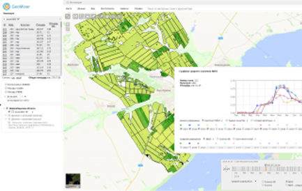
Argo Moniroing Service «CosmosAgro»
GeoMixer Cloud based on Service for Crops indexes and monitor some functionality of farm management software.
Presentation (in Russian)
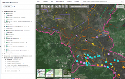
Mapping Services for Management of Hunting Farms
NTRA Farm Hunting Management is carried out on the basis of field survey materials, plans for development and arrangement of specially protected natural areas, mapping data, literature and information reflecting population and condition of hunting resources... Technological capabilities of the Geomixer platform ensure successful implementation of mapping web-services design with any thematic content.
Publication
Based on GeoMixer platform
Geoinformation system (GIS) helps to organize spatial data for many use cases: from search data to sharing maps and coworking. It can be implemented as one of the components of more complicated entire Information system. GeoMixer is a robust and scalable platform for online maps and GIS solutions for which we offer a flexible pricelist and annual support.
How does it work ?
- Imagery acquisition and preprocessing tools
- Panchromatic or bundle products converted into JPEG raster layers. In addition to quicklooks, these allow users to preview imagery in full resolution or limited by zoom levels, to download fragments, or to get imagery as a service for third-party applications
- The main GeoMixer-based user application serves to search imagery using a number of filters, to preview images on top of interactive basemaps, to upload AOI shapefiles, etc.
- The storage of imagery products (as files) and metadata (as databases) can be deployed in the cloud or in the enterprise network.
- Notifications of imagery updates for certain areas of interest predefined by user subscriptions.
- Third-party applications users who can get access to RGB imagery and metadata via standard program interfaces like WMS / WFS.
GeoMixer Editor
The application is designed to perfom main operations with spatial data: upload, customize styles, delegate rights etc. Also is used as base UI viewer to browse created maps, to interact with data and to use tools and services.
GeoMixer API
Program interface to embed GeoMixer maps into client-side applications, customize user interface and to add additional components and plugins.
GeoMixer Server
GeoMixer's backend to manage data into Database, to optimize it for better perfomance and many more Server-side operations like WMS, WFS data export and so on ..
GeoMixer platform for enterprise GIS development
- Amazing web-based perfomance of big data in vector formats (like gpx tracks. multitemporal data like tracking or satellite imagery)
- Propriatary or opensource backend environment (MS SQL Server / Prostgre SQL)
- Scalable architecture for enterprise and cloud-base solutions
- Base maps and open data (like Openstreetmap)
- Easy customizable UI using API and opensource components like Leaflet
- Tech support and users community, tutorilas, case studies, webinars
Use individual method and learn from others. We can analyze your business taks and consult you regarding best practice of GIS integration and usage.
Case Studies
Russian Geoportal «Kosmoplan»
Multipoject system to support decision makers and operators in Emercom. Contains various data sets and connection services. Pluged with VPN into Scanex network to get the operative satellite imagery acquired and processed by Scnaex.
Publication
GIS for agriculture control "Demetra"
The united system for agriculture activities control by "Rosselhoznadzor". Integrates several subsystems for information support of state control.
View
in Blog (in Russian)
Publication